
- home
- europe map
- italy map
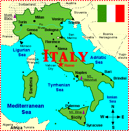
Map of Italy


Navigate map of Italy, Italy country maps, satellite images of the Italy, Italy largest city maps, political, physical map of Italy, driving directions and traffic maps.


Map of Italy


Related Maps of Italy and Italy Satellite Images


Largest Cities Map of Italy
Rome Map - 2,872,021 Milan Map - 1,337,155 Milano Map - 1,337,155 Naples Map - 978,399 Palermo Map - 678,492 Genoa Map - 592,507 Bologna Map - 386,181 Florence Map - 381,037 Bari Map - 327,361 Catania Map - 315,601 Cesena Map - Como Map - Ferrara Map - Brescia Map - Brindisi Map - Cagliari Map - Bergamo Map - Ancona Map - Napoli Map - Roma Map - Foggia Map - Forli Map - Modena Map - Monza Map - Imola Map - Latina Map - Livorno Map - Messina Map - Parma Map - Perugia Map - Pesaro Map - Pescara Map - Piacenza Map - Pisa Map - Prato Map - Ravenna Map - Novara Map - Padua Map - Salerno Map - Sassari Map - Siracusa Map - Taranto Map - Terni Map - Treviso Map - Trieste Map - Udine Map - Venice Map - Verona Map - Vicenza Map -Italy Google Map, Street Views, Maps Directions, Satellite Images
GuideoftheWorld.net offers a collection of Italy map, google map, Italy atlas, political, physical, satellite view, country infos, cities map and more map of Italy.
Largest Cities' Map of Italy
Rome Map Milan Map Milano Map Naples Map Palermo Map Genoa Map Bologna Map Florence Map Bari Map Catania Map Brescia Map Brindisi Map Cagliari Map Bergamo Map Cesena Map Como Map Ferrara Map Ancona Map Salerno Map Sassari Map Siracusa Map Taranto Map Terni Map Novara Map Padua Map Modena Map Monza Map Foggia Map Forli Map Imola Map Latina Map Livorno Map Messina Map Parma Map Perugia Map Pesaro Map Pescara Map Piacenza Map Pisa Map Prato Map Ravenna Map Napoli Map Roma Map Treviso Map Trieste Map Udine Map Venice Map Verona Map Vicenza MapCopyright GuideofTheWorld.Net 2006 - 2023. All rights reserved. Privacy Policy | Disclaimer